


About GLOS
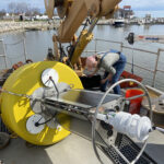
The School of Freshwater Sciences currently operates 3 seasonal environmental monitoring buoys in Lake Michigan as part of the Great Lakes Observing System (GLOS). Historically, two monitoring buoys have been deployed off of Atwater Beach in Milwaukee, WI. As of 2019, only 1 buoy at the 20-meter depth site will continue to be deployed. The larger 10-meter buoy is considered to be retired. Another monitoring buoy is located in south-central Green Bay, WI. Green Bay monitoring is conducted in collaboration with the Fox-Wolf Watershed Alliance (FWWA) and affiliated partners. SFS also conducts environmental research and monitoring in collaboration with the US National Park Service at Sleeping Bear Dunes National Lakeshore, where an additional buoy is deployed seasonally, and the Apostle Islands National Lakeshore. Additional environmental monitoring of Lake Michigan is conducted in collaboration with the Lake Express high-speed ferry as well as the North Shore Water Commission.
These monitoring programs produce a variety of data including over-lake weather measurements, wave height, current speed and direction, and water quality measurements such as temperature, conductivity, oxygen concentration, carbon dioxide concentration, pH, and chlorophyll concentration. Each buoy is also equipped with either a surface or benthic camera, which transmits images at 10 minute intervals to our Dashboard page.
The overall objective of this GLOS effort is to increase Lake Michigan observing capacity, which will lead to improved wave forecasting, over-lake weather forecasting, and circulation modeling. The monitoring systems also provide data for the validation and improvement of air quality (ozone) forecast models, monitoring of long-term changes in nearshore water quality, and water quality decision support tools for managers at the municipal, state and federal levels.
News
- Monitoring change on Wisconsin’s Shipwreck CoastResearch Specialist Jessie Grow was featured in a recent Environmental Monitor article on the development of National Marine Sanctuary's "Shipwreck Sentinel" buoy. Grow is part of a collaborative effort by UWM-SFS and NOAA working on the Wisconsin Shipwreck Coast Sentinel project in Sheboygan, Wisconsin. It aims to deploy a real-time system to improve forecasting, support …
- Buoys featured in GLOS’s first “Buoys of Summer” write-upUWM School of Freshwater Sciences buoys are featured in Great Lakes Observing Systems' first "Buoys of Summer" feature in their monthly newsletter. Research specialist Jessie Grow was interviewed and shared more about the operations. The University of Wisconsin-Milwaukee School of Freshwater Sciences is home to certified freshwater superstars. And their buoy program? May simply be the best in …
- Deploying data buoys for public use in Lake MichiganWisconsin Shipwreck Coast National Marine Sanctuary has been busy installing the 16 mooring buoys for the 2025 season. Next up, the NOAA sanctuary staff is preparing to assist with the deployment of data buoys off the coast near Two Rivers, Sheboygan, and Port Washington. In partnership with Michigan Technological University, the University of Wisconsin-Milwaukee School …

- jgrow@uwm.edu
- 414-382-1700
- GLRF Main Building 180