Atmospheric Science Research
Atmospheric Science faculty and students collaborate closely in a wide range of atmospheric research. Graduate students conduct research in support of their M.S. thesis or PhD dissertation, and undergraduate students can become involved in research, whether for credit or salary, early in their studies. Students are encouraged to directly contact the faculty member or members leading the research area of interest.
Air Pollution Meteorology
Air pollution meteorology deals with meteorological processes occurring close to the Earth’s surface, including the effects of meteorology on air pollutants and the effects of pollutants on meteorology.
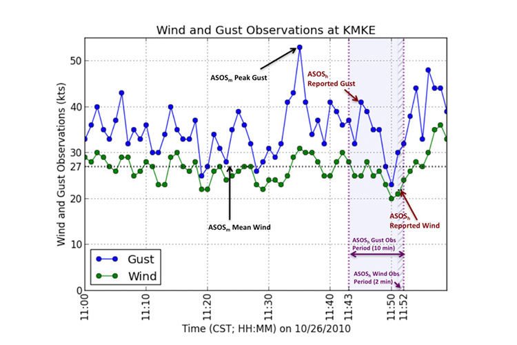
Professor Jon Kahl’s research group studies the adequacy of the popular Pasquill classification scheme for characterizing atmospheric stability, meteorological influences on toxic air pollutants in Mexico, models for describing the long-range transport of atmospheric contaminants, methods of measuring atmospheric particulates using satellites, and methods of characterizing and forecasting wind gusts.
Climate Dynamics
Will the Earth’s polar ice caps melt and result in the onset of a new ice age? Will the frequency or intensity of hurricanes and mid-latitude cyclones increase in the near future? The field of climate dynamics research has developed rapidly in recent decades.
Professor Sergey Kravtsov’s research group addresses a wide spectrum of climate dynamics problems using a hierarchical modeling approach and advanced statistical analyses. Examples include the development of extremely numerically efficient, data-driven weather emulators; the robust identification of forced and internal components of climate variability in state-of-the-art climate models and observations; and skillful simulation of the Great Lakes climate regimes using an improved coupled lake-ice-atmosphere model.
Data Analytics
The ability to leverage data to improve understanding has become increasingly relevant as data becomes more readily available across a wide range of fields and areas of natural and human activity. Most data scientists require several skills: disciplinary expertise, higher level mathematics and statistics, and computer programming.
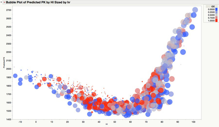
Professor Paul Roebber leads research that applies the principles of data science to atmospheric science questions including the prediction of peak electricity demand; the generation of improved deterministic and probabilistic nowcasts and short-range forecasts of precipitation, convection, severe weather and tropical storm intensity; temperature forecasts; as well as questions in other fields such as professional sports (e.g., “Is there such a thing as momentum in the NFL or the NBA?” and “What is the contribution of penalty calls to home field advantage in the NFL?”).
Extreme Weather
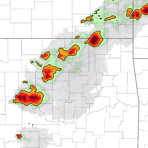
When you think about your experiences with the weather, it’s often an experience you had with intense phenomena such as thunderstorms, squall lines, tropical storms and hurricanes that is the most memorable. The small-scale atmospheric processes that influence these features make them challenging to both understand and predict.
Led by Professors Clark Evans and Paul Roebber, faculty and students at UWM are at the forefront of the high-impact weather research and operations communities. Our research has advanced our understanding of and ability to predict events such as thunderstorm formation, mesoscale convective systems, tropical storms and hurricanes, midlatitude cyclones, and their associated hazards and societal impacts.