Throughout the years, the AGSL has published a number of cartobibliographies, monographs, and other publications. To order any of the AGSL’s publications and note cards in stock, please email the AGSL staff at agsl@uwm.edu
Publications
Current Geographical Publications Contents (CGPC) is an open access, non-profit service to the scholarly community initiated in 1938 by the American Geographical Society of New York. The index was produced in print between 1938 and 2003. It was available online for a short while but access to that was suspended. Beginning in 2006, the format changed to include the tables of contents (TOC) only.
Compiled by Jovanka Ristic with the assistance of Scott R. McEathron. 2010. 77 p., ill. AGSL Special Publication No. 8 . $15.00, plus tax.
The book offers descriptive entries on over 300 maps in AGSL that were drawn by hand, many of them extremely rare, beginning with its oldest example, the 1452 “Map of the World’” by Venetian cartographer Giovanni Leardo. The Cartobibliography also has entries on AGSL’s printed maps with manuscript annotations, including nautical charts notated by Charles Lindbergh as he planned the first trans-Atlantic flight.
By Norman J. W. Thrower. 2001. 18 p., ill. AGSC Special Publication No. 7. $10.00, plus tax.
This publication is based on Mr. Thrower’s paper “How the West was Mapped” which was the eighth installment in the “Maps and America” lecture series. In this publication, Thrower outlines how, over a period of four hundred years, southwestern North America came to be represented in maps.
Compiled and edited by Christopher Baruth with the assistance of Kathy Blume. 2001. v, 46p. AGSC Special Publication No. 6. $10.00, plus tax.
This bibliography attempts to list all of the publications and reports, large and small, issued either by or on behalf of the American Geographical Society. However, this bibliography does not include reference to the sizable and significant production of maps for which the Society was famous.
Compiled by Scott R. McEathron and Sharon Hill. Edited, and with an introduction by Christopher Baruth. 1996. vi, 30 p., ill. AGSC Special Publication No. 5. *OUT OF PRINT *
This catalog describes over 70 globes or pairs of globes from various institutions and individuals including the AGSL, the Adler Planetarium, the Newberry Library, the Library of Congress, and Arthur Holzheimer that were on exhibit at the AGSL in tandem with a globe symposium held October 23, 1996. The catalog also contains a bibliography of globe related literature that was also part of the exhibit and an index to globe-makers.
By Alexei V. Postnikov. 1995. iv, 35 p., ill. AGSC Special Publication No. 4. $10.00, plus tax.
This monograph is an expanded version of the paper “The Mapping of Russian America” presented by Alexei V. Postnikov on April 13, 1994 as part of the Maps & America Lecture Series at the AGSL. Postnikov surveys the early exploration and resulting cartography of the former Russian America.
By George E. Nunn. Expanded edition with a new essay, “The Test of Time,” by Clinton R. Edwards. 1992. x, 195 p., ill., 2 folding maps. Cloth bound, $15.00, plus tax. Paper bound, $8.00, plus tax.
First published in 1924 by the American Geographical Society as no. 14 in its Research Series, this expanded edition, published in cooperation with the American Geographical Society, reproduces Nunn’s original four chapters and concludes with a new chapter examining Nunn’s work in the light of his own later contributions and those of other scholars.
Compiled by Clinton R. Edwards and Damon Anderson. 1992. 26 p., AGSC Special Publication No. 3. $5.00, plus tax.
The American Geographical Society Library’s resources on Columbiana are extensive, reflecting the Society’s strong interest in exploration and discovery. This bibliography lists over 400 books and reprints of journal articles published from 1616 through 1992.
By J.B. Harley. 1990. 160 p., ill. $15.00, plus tax.
Created by the late, internationally renowned scholar J. Brian Harley as an exhibition guide, this book stands alone as a popular introduction to the cartography of Europe and the Americas in the 14th, 15th and 16th centuries. Supply is limited.
Exhibition Videotape. 29 minutes, 1/2 inch VHS videotape. $5.00, plus tax.
Uses the maps and illustrations of the exhibition “Maps and the Columbian Encounter” to reveal the competing ideologies, technologies, and political ambitions which shaped the Encounter for both American Indian and European societies.
Edited by Lutz Holzner and Jeane M. Knapp, 1990. ix, 22 p., ill. AGSC Special Publication No. 2. $5.00, plus tax.
This publication honors Professor Harold M. Mayer, a noted urban geographer, a faculty member at the University of Wisconsin-Milwaukee, a long-time friend of the American Geographical Society, and a user of the AGSL. It includes Mayer’s essay “A Half Century of Urban Geography in America: Retrospect and Prospect,” a bibliography of his work, and a history of the geography department at the University of Wisconsin-Milwaukee.
Edited by Ellen M. Murphy and Jeane M. Knapp, 1990. xiii, 115 p., ill. AGSC Special Publication No. 1. $5.00, plus tax.
Kaleidoscope of History is a guide to the Golda Meir Library’s extensive photographic holdings, over 260,000 images, with information on how researchers can gain access to these extraordinary visual resources. It focuses particularly on the historic photographs in the AGSL and includes the research papers of four University of Wisconsin-Milwaukee faculty members who participated in “The American West Revisited,” a NEH-funded project to rephotograph the sites recorded by Timothy O’Sullivan in his magnificent views of the American West in the 1860’s and 1870’s.
Edited by Lutz Holzner and Jeane M. Knapp, 1987. xiv, 376 p., ill. $5.00, plus tax.
Soviet Geography Studies in Our Time honors UW-Milwaukee Professor Paul E. Lydolph for his accomplishments in the fields of Soviet geography and climatology. Contributors are Andrew R. Bond, Leslie Dienes, R.A. French, Chauncy D. Harris, Robert A. Lewis, Philip P. Micklin, Victor L. Mote, Robert N. North, Judith Pallot, Philip R. Pryde, Theodore Shabad, Denis J.B. Shaw, Joerg Stadelbauer and Craig ZumBrunnen.
Note Cards
- Individual card with envelope, $2.00, plus tax.
- Packet of six with envelopes, $10.00, plus tax.
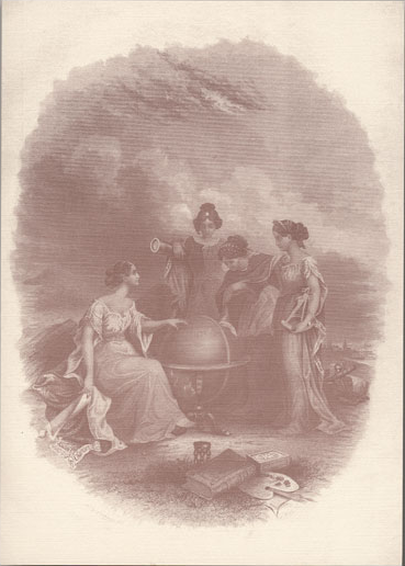
Colton Notecards
This frontispiece from Colton’s 1868 General Atlas was drawn by Frederic A. Chapman. The objects in the foreground, which include an artist’s palette and a compass, seem to suggest the idea of cartography as both an art and a science. The female figures may symbolize “muses” of the arts and sciences.
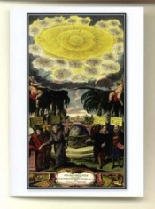
Doppelmayr Notecards
Full color frontispiece from Johann Gabriel Doppelmayr from Atlas novus coelestis, 1742. In recognition of the 2009 International Year of Astronomy.
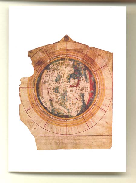
Leardo Map Notecards
Full color reproduction of Giovanni Leardo’s 1452 Mappamundi on a fine-quality note card.
Perhaps the finest example of a medieval world map, or mappamundi, preserved in the Western Hemisphere, the Leardo map of the world is the oldest original map in the AGSL.
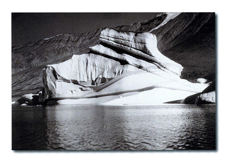
Louise Arner Boyd Glacier
Iceberg, Kjerulf Fiord, East Greenland. Photograph by Louise Arner Boyd (1887-1972), a ground-breaking but little-remembered female Arctic explorer, on the first of her four expeditions to that region, August 1931.
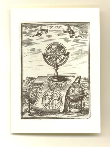
Mallet Engraving Notecards
Reproduction of “Equateur,” an engraving in the first volume of a five-volume set by Allain Manesson Mallet, published in 1683.
“Equateur” illustrates the concept of the equator and its importance for navigation and time determination.
The set “Equateur” appears in, titled “Description de l’univers contenant les differents systemes du monde,” contained numerous maps, views, portraits and illustrations such as the one depicted on this note card.
Ortelius Engraving Notecards
An example of Renaissance decorative art, this engraving reproduction is from Abraham Ortelius’Deorum dearumque capita…, a work published in 1602 which depicted a series of engravings of Classical gods and goddesses. Ortelius based the engravings on images from ancient coins he had collected during his extensive travels.

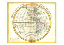
Rizzi-Zannoni Map Notecards
This card features a map from a small 1762 pocket atlas in the collection of the American Geographical Society Library. The atlas was produced by Giovanni Rizzi-Zannoni who was a leading French cartographer in the 18th Century.