A question about OSHA regulations may have led to a revolution in weather forecasting.
In 2016, UWM’s Innovative Weather Center, a student-staffed agency that provides custom forecasts, was soliciting the Milwaukee Brewers as a possible client. The Brewers’ stadium features a retractable roof. When it opens or closes, the team needs staff members up high to oversee the operation.
But OSHA has strict guidelines about the wind conditions that workers may be exposed to. The Brewers wanted to know: Could Innovative Weather predict peak wind gusts around the ballpark?
“I looked into it and learned that not only do I not know how to forecast wind gusts, but nobody knows,” said UWM atmospheric sciences professor Jonathan Kahl. “There’s no consistency in the available methods and there’s no testing of the accuracy of those methods.”
Kahl is not affiliated with Innovative Weather, though he works closely with the UWM faculty members who run the organization. After the Brewers posed their question, Kahl and Austin Harris, his Master’s student at the time, set to work to find a model that could answer it.
Filling in the missing data
Wind gusts are caused by vertical air movement when fast-moving air high in the atmosphere moves downward toward the earth, bringing its momentum with it. Because they’re over so quickly and because scientists can’t easily measure vertical wind speed, it’s hard to predict the top speed of a wind gust.
To do so, scientists have compiled historical and current data from weather stations around the world to build models to estimate gusts, but there’s a problem with that information.
“In the standard hourly weather reports that operational forecasters use … the reported wind speed is the average wind speed during only two minutes of the hour. The wind gusts are only reported if certain criteria are met. If the wind gust is reported, it refers to wind gusts during only 10 minutes of the hour,” Kahl explained.
In other words, it’s likely that scientists are missing the strongest wind gusts.
So, to build his forecasting model, Harris had to gather minute-by-minute historical wind speed data for Milwaukee – 60 measurements an hour; 1,440 measurements a day; 525,600 measurement per year; and over 4 million measurements for eight years’ worth of data.
A model prediction
Though there are several existing methods to predict peak wind gusts, no one model is more accurate than the others. For ease of use, Harris decided to improve on an existing model called the Gust Factor Method.
“A gust factor is just a fraction: the (speed of the) wind gust divided by the wind speed,” said Kahl.
Say that Milwaukee has a gust factor of 1.6. That means that on average, a wind gust in Milwaukee is 60 percent faster than the wind speed. If you have a forecast for the wind speed, you can estimate peak wind gusts by multiplying the wind speed by the gust factor. A 10-mph wind would yield a 16-mph wind gust prediction, for example.
“What (Austin) found was that the gust factors change depending on the weather conditions,” Kahl said. “In Milwaukee, for example, when the wind is from the east or the northeast, the gust factor is relatively small – like 1.5. When it’s from the west or the northwest, then the gust factor zooms up to close to 2.”
That’s thanks to the surrounding surfaces. Wind blowing off of Lake Michigan typically has a smooth, flat ride over the water into the city. Wind from the west must travel over an uneven landscape and buildings, giving rise to larger vertical air motion, and thus, more wind gusts.
“What (Harris) found is that wind speed and direction cause the greatest changes in the gust factor,” Kahl said. “He showed that if the wind speed forecasts are perfect, then this gust factor method would give very good gust forecasts.”
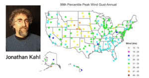
Testing accuracy across America
Kahl calculated gust factors at 15 locations across the United States. Then he tested Harris’ model. It worked; for about half the sites, the model was able to predict peak gusts out to three days in the future, and out to 24-36 hours into the future at the other half of the sites.
Kahl published his findings last year, but the research wasn’t done. The model works, but only if meteorologists know the wind gust factors in their area.
“Our method to determine those gust factors requires an analysis of 4 million one-minute wind observations just from one location. It’s time consuming and complicated,” Kahl said.
Brandon Selbig was up to the challenge. An atmospheric science major, Selbig is working toward his second bachelor’s degree after moving to Milwaukee and deciding to switch careers. When Kahl offered him a chance to help with research, Selbig was thrilled.
“I’ve wanted to be a meteorologist since I was 14,” Selbig said. “Undergraduate research was not even an option at my last school due to my involvement in sports, and was not done in the way that UWM does it with paying student researchers while they gain experience.”
Selbig and Kahl identified 178 sites around the nation where they wanted to calculate the gust factor to test the prediction model. Selbig wrote computer scripts to capture the minute-by-minute wind speed observations recorded over the last 8 years at each locale.
Using that information, “We made ‘gust webs’ for the gust factors. It’s basically a spider plot. You have north, east, south, and west, and then rings of 0-5, 5-10, 10-15 and greater than 15 knots for a wind speed,” Selbig explained. “The gust webs say that if you can forecast what a wind speed might be at a time and what direction it will be coming from for a certain site, you can pretty accurately predict what the wind gust will be.”
Selbig plans to present parts of his research at UWM’s Undergraduate Research Symposium in April. Kahl has just submitted another paper detailing their findings, and the pair have also built a website showing the gust factors for the 178 locations they calculated. Eventually forecasters across the country might be able to use that data and Harris’ model to predict peak wind gusts in their own cities.
In the meantime, Kahl and Selbig are tackling the next step of their research.
“Another Masters student, Teresa Turner, did a project to evaluate the skill (accuracy) with which a model predicts peak wind gusts in Milwaukee during specific gust-producing weather phenomena,” Kahl said. “She showed that for Milwaukee, the model was skillful for most of those conditions.
“Brandon and I are taking Teresa’s results and adapting them to the 15 sites I used in last year’s paper. How well does the model perform in specific types of weather conditions?”
The answer, my friend, is blowing in the wind.
By Sarah Vickery, College of Letters & Science