Professor Judith T. Kenny, Department of Geography, University of Wisconsin – Milwaukee
Introduction
Many places claim the title “the city of neighborhoods,” – New York, Boston, Chicago, St. Louis, Portland (Maine) and Roanoke (Virginia) – to name a few. By emphasizing neighborhoods as their building blocks, these cities celebrate community as well as the diversity of both their residents and living environments. Many Milwaukeans express similar sentiments, and although the “city of neighborhoods” title has not been adopted for any official purpose, few Milwaukeans describe their city without detailing the variety and significance of neighborhoods in their hometown. On the positive side, we hear about the value of traditional, walkable, mixed-use, and human-scale neighborhoods with shops and meeting-places suited to various lifestyles. On the negative side, the focus shifts to uneven development and a separation of residents defined by racial segregation. Taken together, the positive and negative suggest why Milwaukee has been labeled both “Genuine American” and a microcosm of America’s economic and social malaise.1
Gaining a better understanding of Milwaukee’s neighborhoods is certainly an important step in sorting out the complex strengths and weaknesses of the city. And although the quality of today’s 75 officially recognized neighborhoods is inevitably caught up in the larger context of economic and social change, it is also shaped by the nature of each neighborhood’s original development. With that in mind, and supported by the rich resources available in this digital collection, we might “picture” Milwaukee’s neighborhoods in terms of the city’s growth and development over time. The maps provided as part of this collection allow us to analyze that development in great detail. But to begin, a few generalizations might be made about the city’s size during four different periods. Four phases of the growth shaped Milwaukee’s neighborhoods: the commercial city (before 1880); the industrial city (1880-1920); the early automobile city (1920-1945); and, the post-World War II city (1945 – present).
| Year | 1840 | 1880 | 1900 | 1920 | 1940 | 1960 |
| Population | 1,712 | 115,587 | 285,315 | 457,147 | 587,472 | 741,324 |
Early Commercial Milwaukee
Incorporated in 1846, Milwaukee began as a commercial city focused on trade and primarily the processing and movement of agricultural goods. Approximately seven square miles, the city was limited in size by both its relatively small population and the dominant mode of transportation (walking). The built-up area of Milwaukee included today’s downtown and land within approximately one to two miles of the heart of the city. Juneau Town, Kilbourn Town and Walker’s Point, the earliest neighborhoods and rivals for real estate development, made up the young city’s core.
Divided into three major areas by the Milwaukee and Menomonee Rivers, the city historically has been described in terms of the East, North/West and South sides. As early as 1853, an observer noted the remarkable degree of ethnic and economic segregation that existed in Milwaukee. Because Milwaukeans themselves ascribe distinctive and definite character to these sectors, it would be easy to exaggerate the geographic divides. But the historic roots of these differences require some attention. From an early date (the 1840s), Byron Kilbourn’s recruitment of German immigrants to the west bank of the Milwaukee River marked that territory as the heart of German Milwaukee; while Juneau’s east bank settlement tended to be associated with New Englanders and New Yorkers – the Yankees, in the local parlance.2 The location of industry along the major rivers further defined the city by ethnicity and class. Walker’s Point, to the south, lagged behind during this period as its owner George Walker dealt with claim disputes.
Industrializing Milwaukee
Milwaukee’s transformation from a commercial trade center to a manufacturing economy was completed by the 1880s. Around 1881, Milwaukee adopted the title “workingmen’s city” and claimed the status of “the city that works.” Statistics confirmed the relative strength of its manufacturing sector in 1910 when, although ranked twelfth in population, it ranked third among American cities based on the proportion of its work force in industry. Only Buffalo and Detroit had a higher portion of manufacturing employees. Historic Milwaukee firms included not only the beer companies of Pabst, Schlitz and Blatz Beer, but also such firms as Allis-Chalmers, Evinrude, Briggs and Stratton, and Harley-Davidson.
Industry tended to locate along the city’s rivers and the rapid population growth associated with this period of industrialization was accompanied by new working class neighborhoods adjacent to. At the same time, horse-drawn streetcars and then electric trolleys facilitated the expansion of middle-class neighborhoods by providing a means of commuting from the downtown’s commercial area out to what was then the city’s periphery.
Panoramas taken from the downtown courthouse in 1885 remind us that industry was never far from the city’s commercial and governmental center. City Hall, constructed in 1895, was one of the world’s tallest buildings at the time and it reflected a genuine civic pride along as well as the German heritage of many of the city’s residents.
At the turn of the century, the “workingmen’s city” also enjoyed the distinction of being a “foreign-born” city. In 1910, Milwaukee and New York shared first place in terms of the percentage of population who were foreign-born. In particular, the large German and Polish communities marked Milwaukee as a city of European-born residents. In 1891, expressing both bigotry and civic boosterism, one resident stated:
The German and Polish population outnumbers the native probably three to one, and in nine cases out of ten this might be a cause for alarm, but – not in Milwaukee. Polack, Hungarian, Prussian, Bavarian, Wurtemburger, it makes no difference. There is not of its size in all America a city that contains a population more self-respecting, more law-abiding, more cheerful and content than Milwaukee, and you have only to ride or drive through these great sections to see the reason – there isn’t a real tenement house in the town.
Homeownership is a virtue, he concludes, because “no matter how humble it may be, it is the home that makes the citizen who has the public interests at heart.”
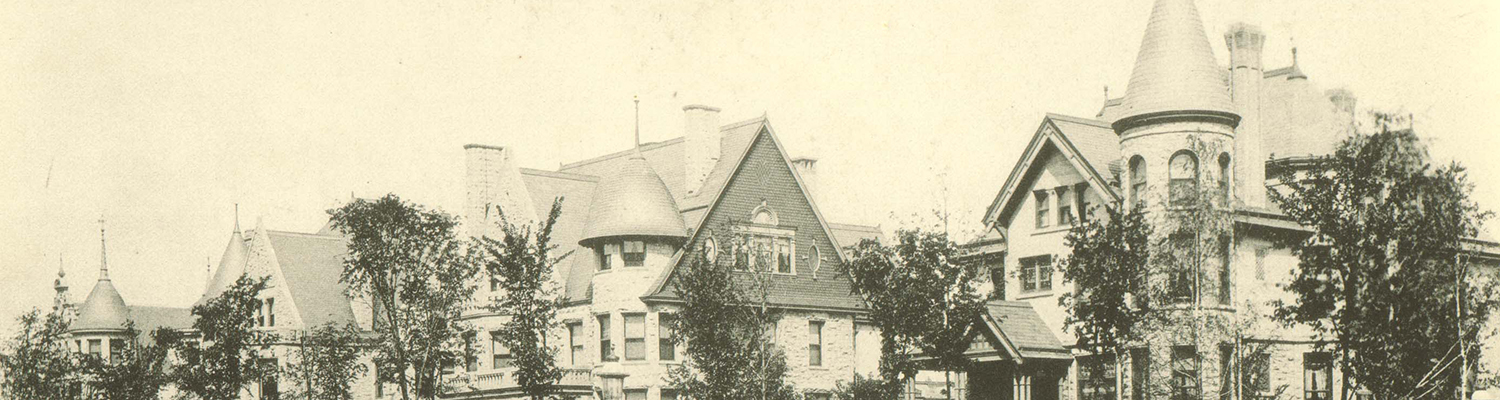
Beyond this generalization about the overall quality of Milwaukee’s neighborhoods, distinctions might be made. One of the oldest neighborhoods on the East Side, Yankee Hill (uphill from Juneau Town), highlights the relatively wealthy group historically associated with this sector. The construction of Milwaukee’s “Gold Coast” to the northeast along the bluff overlooking Lake Michigan underscores the relationship between the middle-class and wealthier East side residents. Prospect Avenue suggests more than the benefits of a lake view. Today, this once grand residential street is lined by high-rise apartments interspersed with the mansions of Milwaukee’s late- nineteenth-century business leaders.
The other two sectors – the Northwest and South Side – retained their association with Milwaukee’s two large ethnic groups for an extended period. As stated in 1891, ” . . . the southwestern section of our city is all Poland; the northwestern all Germany . . .” By the turn of the century, nearly two-thirds of Milwaukee’s large, occupationally mixed German population lived on the Near North Side. And although present throughout the city, successive German neighborhoods tended to migrate north and west of this initial commercial, industrial, and residential core. Many of Milwaukee’s most prosperous German families built along Highland Boulevard and major companies founded by Germans – such as Pabst (until 1996), Usinger’s, and Schlitz (until 1984) – maintained their centers of operation nearby on the Near North Side.
The Poles also founded neighborhoods in various sectors of the city – adjacent to industry that provided jobs for unskilled workers and on land that was affordable. Located near Milwaukee River factories, the Brady Street and Riverwest neighborhoods were settled by the Poles. However, they made the biggest impact on the city’s south side. The first wave of Polish immigrants arrived in the 1870s bringing fewer skills that might be immediately transferred to an industrial economy. Consequently, and in contrast to the more mixed population of Germans, the city’s Polish immigrants tended to enter the local labor hierarchy at the bottom. Despite this economic disadvantage, Milwaukee’s Poles also created a landscape shaped by their churches and homes.
One of Milwaukee’s prominent citizens provided the following image of the Polish and their neighborhoods: “they looked toward the wooded lands south of Greenfield Avenue, which they later transformed into a vast area of cottages with high basements, each accommodating two families, with gardens in the rear and some shrubbery and a rest bench in the front.”3 Milwaukee’s Polish homebuilders became agents of landscape change through their reconfiguration of the workers’ cottage. This transformation process produced various forms of the expanded cottage, including the distinctive form of the raised cottage – known in Milwaukee as the “Polish flat.” A 1911 Milwaukee housing study described the typical process of expansion:
In the south side district, . . . the custom is to erect first a four-roomed dwelling (or cottage). When this has been paid for, it is raised on posts to allow a semi-basement dwelling to be constructed underneath. This basement, or the upstairs flat, is then let (rented) out by the owner, who, as soon as funds permit, substitutes brick walls for the timber of the basement.
The particular advantage of the Polish flat was that once the mortgage was paid, the flat could be converted back to a single-family residence. Recently arrived immigrants created a market for rental housing for which the raised cottage was ideally suited. The raised cottage form appears in immigrant working-class areas of Chicago and other midwestern cities as well. Apparently because of its dominance in Polish immigrant neighborhoods, the “raised cottage” earned the title of “Polish flat” in Milwaukee – but only in Milwaukee.
The same features of the industrial/residential landscape that supported the Polish immigrants continued to attract new immigrant populations. Menomonee River Valley industrial jobs attracted small communities of Mexican and Puerto Ricans in the 1920s and 1940s, respectively. Since the 1970s, Hispanic and Asian families have moved into the old South Side neighborhoods. Just as on the South Side, North Side neighborhoods have been in ethnic and racial transition. The Irish, once associated with the Third Ward, created an enclave/neighborhood west of the downtown in the Merrill Park area beginning in the 1870s. Late in the nineteenth century, the Italians took their place in the Third Ward. As the Italian community grew, Italians could be found with the Poles of the Brady Street area. The East European Jewish community, another immigrant group that arrived around the turn of the twentieth century, settled in the Hay Market neighborhood just north of the downtown. This ghetto gave way to another in the early part of the twentieth century. In roughly a square mile of the old German North Side, a clear African-American ghetto began to take shape after World War I.
Until the 1960s, ethnic rather than racial identity distinguished the working-class neighborhoods. The racial character of segregation grew with the relatively recent, dramatic increase of the city’s African-American population. Prior to 1960, African Americans made up less than 10% of the population; today, they constitute approximately one-third of the city’s population and comprise Milwaukee’s second-largest ethnic group. Once immigration from Eastern and Southern Europe was slowed by World War I and changing immigration laws, African-Americans acquired a limited place in the industrial hiring hierarchy. The most rapid growth in Milwaukee’s African American population, however, occurred between 1956 and 1960 when the community grew from 22,000 to 62,000.
The socio-economic pattern of segregation was noted in a 1971 study of class and politics in the United States. Richard Hamilton (1972, 161) summarized Milwaukee’s working-class character with the observation that “A person traveling through the city from north to south would go almost twelve miles without ever passing through a tract with a middle-class majority . . . this working class cluster is approximately three miles wide.” Despite some shifting in the boundaries of the working-class cluster, Milwaukee still retains this degree of segregation by class.
The early Automobile City
Just beyond the neighborhoods of the industrial city, residential development responded to Milwaukeans’ interest in new homes. Thanks to the automobile, the opportunity to move a bit farther away from work was maximized. Bungalows became the house of choice in many of these new neighborhoods. Washington Heights and Sherman Park on the north/west side, Morgandale on the Southside, and infill areas of the Eastside reflect the relative prosperity of a new generation of city residents. In the 1920s, real estate agents advertised that the new Washington Heights neighborhood was for Americans – while a Polish-American real estate agent claimed that the bungalow rather than the Polish flat represented the Polish house of choice.
As the city’s population grew from 1910 to 1930, Milwaukee’s suburbs flourished, and the city competed with its neighbors for new middle-class construction. Relatively modest annexations had added room for additional new development during the first seventy years of the city’s history. Annexation efforts during the years from 1920 to 1940, however, more than doubled its area – growing from 20 square miles to 44 square miles in those twenty years. Vastly greater changes to the scope of Milwaukee’s residential landscape would take place after World War II.
Post World War II
From 1946 to 1967, the city more than doubled in size, increasing from approximately 44 square miles to 96 square miles. Thanks in large part to an assertive annexation campaign lead by Mayor Frank Zeidler, Milwaukee sought to decentralize its population and respond to housing demands while competing with its thriving suburbs. Following the addition of vast acres of farmland, suburban style developments captured the demand for new housing that the war had postponed. Tracts of Cape Cod style houses and then ranch style houses offered Milwaukeans an alternative to the density of the city’s older neighborhoods and allowed them to move out of the city entirely. Granville, on the northwest side, became the single largest acquisition during this period of expansion, adding almost sixteen square miles to the city in 1962.
To the east, along the county line, the Kohl family began to develop the planned community of Northridge in 1969, combining a comprehensive residential community, schools, places of worship and a regional shopping center. Becoming a city within a city, with new residential opportunities in the form of modern apartment complexes and condominiums, Northridge created yet another type of a neighborhood for Milwaukee residents.
With the resolution of the last annexation battles in the 1960s, Milwaukee found itself finally limited by its encircling suburbs. The “iron ring,” as labeled by then mayor Henry Maier, the suburbs had stopped any future growth. After its population zenith in 1960, each successive census indicated loss in city population. Milwaukee’s population fell 15% in 1990 (to 628,088) and then continued to fall, reaching 596, 974 in 2000. Milwaukee’s declining population can be explained in part by smaller family size, but the impact of disinvestments in many older neighborhoods is certainly a big part of the story. Housing stock was lost in the 1960s to interstate construction and urban renewal projects. The march of “progress” became increasingly problematic as citizens began to challenge the consequences of such “improving” forces. By the late 1960s, freeway projects were met with growing hostility. The Park West Expressway was halted at Sherman Boulevard. The Lake Expressway never connected to Interstate 794, while the Park East connection was stopped as it entered the downtown – but not before removing a sizable swath of a working class housing in the Lower Eastside neighborhood. That emptied land would be redeveloped as East Pointe Commons in the early 1990s.
Although disinvestment continues to empty out certain neighborhoods, interest in historic preservation – which was certainly part of the reaction to the “progress” of the 1960s – has contributed to the renewal of many older neighborhoods in Milwaukee. Just as industry left many areas in the city, older neighborhoods – particularly those along the lakefront and Milwaukee river – attracted a diverse new population whose members value their amenities. The list of those rediscovered neighborhoods would be long, but it includes such areas as Riverwest, Brewers Hill, the Lower East Side, the Third Ward, Walker’s Point, Sherman Park, Washington Heights, and Story Hill. Whereas instability and decline once posed a problem, the new worry for many residents of these areas – including those who recently settled there – is that the highly valued socioeconomic diversity might be lost as housing values increase.
Neighborhood change appears to be a constant that Milwaukee residents both deal with and at times delight in. Efforts to understand this process will certainly be enhanced by an ongoing effort to picture Milwaukee’s neighborhoods in their rich variety of detail.
1. Unless otherwise stated, references for material used in this essay may be drawn from: J. Kenny (1995) “Making Milwaukee Famous: Cultural Capital, Urban Image and the Politics of Place,” Urban Geography 16(5), pp. 440-458; and J. Kenny & J. Zimmerman (2004) “Constructing the ‘Genuine American City’: neo-traditionalism, New Urbanism and neo-liberalism in the remaking of downtown Milwaukee,” Cultural Geographies 11(1), pp. 73-98.
2. For further reading on this and later periods of Milwaukee’s development, see John Gurda’s (1999 ) The Making of Milwaukee (Milwaukee Historical Society).
3. For references and further information related to this discussion, see J. Kenny (1995) “Polish Routes to Americanization: House Form and Landscape on Milwaukee’s Polish South Side,” Wisconsin Land and Life (University of Wisconsin Press), and T. Hubka and J. Kenny (1997) “The Workers’ Cottage in Milwaukee’s Polish Community: Housing and the Process of Americanization, 1870-1920,” in S. McMurry & A. Adams eds. People, Power, Places: Perspectives in Vernacular Architecture, VIII (Knoxville: University of Tennessee Press).
Created: March 2004
Last updated: August 2017