While most folks were sleeping off their Thanksgiving turkey and preparing for Christmas, UWM geoscientist Julie Bowles and three of her graduate students were studying volcanoes in the Pacific Ocean.
Or, more accurately, they were studying volcanoes underneath the Pacific Ocean.
Bowles was the Chief Scientist on an expedition aboard the Atlantis, a research vessel owned by the U.S. Navy, to study the Pacific Rise. That’s an underwater mountain range formed by repeated volcanic eruptions over millions of years. The ridge is about a three-day voyage west of Rapa Nui (Easter Island). Bowles, an associate professor of geosciences, hoped to learn more about how often these eruptions occur, how big they are, and how they are distributed along the ocean floor.
Their project, called SPREAD (Southern Pacific Rise Eruptive Accretion Dynamics), was funded by the National Science Foundation. This work is important because scientists still have a lot of gaps in their knowledge when it comes to volcanic eruptions, whether they’re on land or in the water.
“Once a volcano becomes active, there’s a lot of monitoring you can do to hopefully get some signals… that will tell you if it will erupt, but if you’re talking about long-term hazard planning, we really don’t have a good way of doing that,” Bowles explained. “Theoretically, this type of data could help us build those statistical models.”
And, she added, this research will shed more light on the mysterious processes that are happening in the Earth beneath our feet.
Underwater volcano science
As you may recall from your school days, the outermost layer of the Earth is called the crust, and it sits on huge tectonic plates that are slowly, continually moving. When those plates crash into each other, it can cause an earthquake. Volcanoes are also more likely to form at the edges of plates; the fabled “Ring of Fire” sits on the edges of the plates that make up the Pacific Ocean. Where they collide with continental plates, we get volcanoes.
But Bowles isn’t too interested in where the plates meet. She’s more intrigued by where they pull apart.
Beneath the Earth’s crust is the mantle, a layer of hot, slowly-deforming rock. When the plates move apart beneath the ocean, some of the mantle melts, and hot magma erupts to the surface, meets the cold seawater, and hardens into basalt rock.
“So, you form new ocean crust there,” said Bowles. “(It forms) these mid-ocean ridges that snake through all the oceans, these very long, continuous chains of volcanoes. It’s a very regular process.”
That regularity makes them ideal for study, but that presents a challenge. “On land, we can walk around and map out one lava flow here, a boundary there. On the sea floor, obviously, you can’t do that, so we have to use these more high-tech ways of studying it,” Bowles said.
AUVs, HOVs, and more
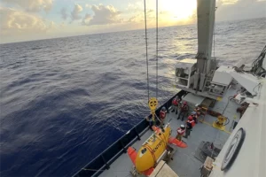
Meet Sentry and Alvin, the high-tech tools that the scientists aboard the Atlantis used to conduct their underwater research.
Sentry is an autonomous underwater vehicle (AUV), a submersible robot that scientists can program to follow a set path. Sentry can travel close to the sea floor to collect data and make high-resolution maps of the underwater terrain “so you can see where there are bumps and faults and little volcanic centers,” Bowles said.
Alvin is the human-operated vehicle. Its titanium sphere was actually forged in Cudahy, Wisconsin, at Ladish Forging (now ATI). Up to three people can fit into the submersible and go beneath the waves to collect samples and see the sea floor with their own eyes. The crew was operating at depths of about 2,800 meters, or 1.7 miles.
“I still haven’t really processed that I was at the bottom (of the ocean),” said Terra Johnson, one of Bowles’ graduate students who went on the voyage. “It looks like a completely different planet down there. There would be huge pillow lavas the size of rooms. Everything down there was supermassive.”
The researchers had planned twenty dives for each vehicle so they could gather as much data as possible. Unfortunately, Murphy’s Law still applies when you’re at sea: What could go wrong, did go wrong.
Research setbacks
At one point, the expedition was delayed by a medical emergency. When the boat got back on schedule, high winds made conditions too dangerous to deploy the AUV and HOV. When the winds died down, the sharks showed up.
“There are two swimmers that have to get in the water when (the Alvin) is deployed to disconnect the cables,” Bowles said. “The sharks were displaying a lot of aggressive behavior, so the decision was finally made that we’re not putting people in the water.”
Luckily, the researchers had one more tool up their sleeve.
“Rock coring is a less sophisticated way of getting physical samples,” said Bowles. “It’s basically a big metal weight, and it has these little blobs of wax on the bottom. You drop it to the sea floor, and it smashes into the lava rocks. That volcanic glass is very brittle and breaks off into the wax.”
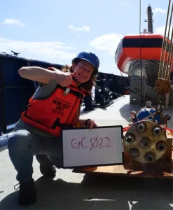
Graduate student Mike Anderson got good at rock coring.

“My initial job was rock coring,” he sighed. “I was on (that job) for a while because of the delays.” Anderson also assisted with mapping the sea floor and acted as an extra set of hands for the researchers.
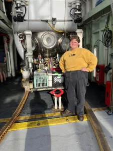
Graduate student Vera Soltes’ main job was to analyze the samples that came back from rock coring. “We would have to clean them up and describe them. We would weigh them and cut them open with a rock saw,” she explained. “We’d say what kind of rock it is, what the grain size is, what are the mineral components, if there’s any weathering.”
Soltes and Johnson are both interested in magnetic elements of the rock samples, which can help scientists identify the age of a particular rock and the ridge where it was found or the pattern of a lava flow.
Life at sea and back on land
While researchers could, and did, operate the rock corer nearly 24 hours a day, there was plenty of time for enjoying the sailor’s life. The researchers and the ship’s crew played board games, stargazed, baked, and had a fierce table tennis tournament. They commiserated when sea sickness laid anyone low.
Now that they’re back on dry land, they’ll spend more time analyzing the samples they could obtain. Not only will their finds shed light on volcanic processes, but they might learn some things about biology as well, said Bowles. Oftentimes, hydrothermal vents will pop up near these underwater volcanic ridges, and bacteria can use the chemicals from the vents to create their own energy. Other sea life feeds on the bacteria. Biologists are interested in these ecosystems and chemical processes.
It’s one more example of why these types of expeditions are important. So much of the earth is covered by water, said Bowles. If we’re going to truly understand our planet, we need to know what’s happening beneath the surface.
More photos from the expedition are available on SPREAD’s photo gallery.
By Sarah Vickery, College of Letters & Science