Geospatial Occupations Outlook
- Department of Labor Occupation Summary Report
- U.S. Department of Labor, Career OneStop
- U.S. Bureau of Labor Statistics
- U.S. Department of Labor, Employment & Training Administration
- The Changing Geospatial Landscape – A Second Look
- National Spatial Data Infrastucture Stategic Plan, 2014-2016
Salary Information
- URISA Salary Survey: check the most current year.
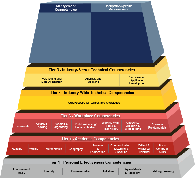
Geospatial Competency Model

Job Titles and Fields
Note: GIS and Geospatial my be used interchangeably in job titles
Cartographer
Crime Analyst
Economic Development Specialist
Emergency Preparedness Specialist
Environmental Scientist
Geographer
GIS Analyst
GIS Consultant
GIS Coordinator
GIS Developer
GIS Instructor
GIS Programmer
GIS Project Manager
GIS Sales & Marketing
GIS Software Engineer
GIS Spatial Analyst
GIS Specialist
GIS Supervisor
GIS Technical Writer
GIS Tech Lead
GIS Technician
GIS Tester
GIS Web Administrator
Hydrologist
Imagery Acquisition Specialist
LiDAR Project Manager
Public Health Specialist
Research Program Manager
Scientist
Surveyor
GIS Certification
- American Society for Photogrammetry & Remote Sensing (ASPRS) Certification
- GIS Certification Institute
- ESRI Technical Certification
- Professional GEOINT Certification
Geospatial Revolution
The Geospatial Revolution Project is an integrated public service media and outreach initiative about the world of digital mapping and how it is changing the way we think, behave, and interact.