UWM operates both a digital seismometer which is housed in a specially designed vault in the basement of Lapham Hall. The instruments rest on a pillar of concrete that extends down 30 feet to help isolate urban noise from transient signals. Unfortunately the bedrock in this area is too deep (~200 ft) for the pillar to extend down to it so some urban noise is found in the signals. The digital seismometer is connected to a Dell PC that continuously records seismic data. The digitizer clock is is kept accurate with the help of a GPS sensor that is constantly feeding the current time.
Digital Seismometer Specifications
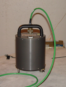
- Sensor: Guralp Broadband CMG-EDU-T
- Latitude: 43.07611 North
- Longitude: 87.88455 West
- Elevation: 205 meters
Digital Data is collected at 1 sample/second for teleseismic earthquakes and 40 samples per second for regional earthquakes.
Earthquake Links
- USGS (U.S. Geological Society)
- Earthquake Science Timeline (USGS)
- IRIS (Get EQ data from around the world)
- Mid America Earthquake Center
- ORFEUS (European EQ data center and more)
- SCEDC (Southern California EQ Data Center)
- St. Louis University Earthquake Center
Topographic Data
- GLOBE (30-sec data; National Geophysical Data Center)
- ETOPO2 (2-minute data; National Geophysical Data Center)
- Bathymetry, Topography, and Relief (National Geophysical Data Center)
- All types of data (National Geophysical Data Center)
Earthquake Utilities
- Drumplot (Guralp Systems, program to plot digital data)
- GMT (Generic Mapping Tools, U. of Hawaii)
- IRIS Software Library
- Latitude and Longitude Converter (FCC website)
- Seismic Analysis Code Users Manual (Seismic Analysis Code, IRIS)
- SCREAM (Guralp Systems, realtime acquisition and monitoring)
- Seismic Waves (download it, Alan Jones, SUNY Binghampton)
- Seismic Eruption (download it, Alan Jones SUNY Binghampton)
- TauP (Java Applet for Calculating Travel Times; University of South Carolina)
- USGS Software Library
- WILBUR (Web Based Event Request Method from IRIS)