Whenever federal or state agencies undertake a new building project, they are required by federal, and often state, laws to consider their impact on any historical resources in their vicinity before they begin.
Those laws help keep Allison Densmore employed.
Densmore is a graduate student working toward her Master’s in anthropology at UWM. She’s also an archaeologist with the Illinois State Archaeological Survey (ISAS), an agency that provides cultural resource management services to entities like the Illinois Department of Transportation and others that must comply with historic preservation laws.
She sat down to talk about her education, her work, and her love of archaeology.
First things first: Where are you from and what inspired you to pursue anthropology?
I’m from Elgin, Illinois, which happens to also be where my job is. I came (to UWM) for my undergrad in 2017 and graduated in three years, and then went straight into the Master’s program.
For anthropology – I’ve always thought people were cool. I originally started out doing cultural anthropology, which is more like ethnography and (studying) living people, but then I did an archaeology field school through UWM at Aztalan State Park in Lake Mills. I was like, whoa! This is so much cooler.
What was it about field school that drew you in?
To me, it was cool to be super handson. I like writing; I like the academic side of things. But I think practice and getting dirty – literally – on the archaeology side of it is really cool. It’s cool to find things that no one else has found before, and to put yourself in the shoes of the people that used to live there.
(We also worked with) groundpenetrating radar and instruments, and that’s how I got into GIS, which is Geographic Information Systems (working with software to attach datapoints to points on a map). I’m doing a certificate in GIS as well.
You’ve found a cool way to put those skills to use. Tell me about your job with the Illinois State Archaeological Survey.
ISAS is actually run through the University of Illinois at Champaign. There so happens to be a field station in Elgin, Illinois, which is 10 minutes from my house. … I found out about the job last year and was like, duh, of course I’ll do that! It makes it really easy to live at home for free.
What exactly is cultural resource management? What kind of work do you do with ISAS?
Cultural resource management is all about finding archaeological sites before people destroy them. At ISAS, we are contracted through the Illinois Department of Transportation (IDOT). Any time they are expanding a road, building a road, doing anything with roads, we go out there ahead of time and check out their proposed building site. That way, we can be sure that we’re protecting what we can and recording whatever information we can collect before it gets destroyed.
What is the process for doing your job?
It’s a pretty long process. We get documentation (from IDOT) that says, hey, we have plans to build this road. From that point, we’ll look at maps. We’ll look at historic aerial imagery … We’ll refer to our (files) with known archaeological sites..
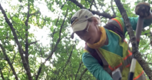
Once we have our study area figured out – and that can be tricky because the Department of Transportation changes their mind about what they want to do all the time – then we’ll send people out in the field. We can do a pedestrian survey, which is just walking and scanning the ground, or shovel testing, which is digging a hole every couple of meters.
From there, depending on what we find, we write up a big report that will contain an essay about the history of the area, what we ended up finding, what the ecology is like, and then we send it off to them. There are a few different reasons why we might say, ‘For sure, don’t dig here!’ and we’ll put that in a report.
And IDOT has to listen – they are required by law, it seems.
They literally have to pay us to look at these areas. It’s good job security in that sense. … So much destruction has taken place already, so a lot of cultural resources are far-gone at this point. Our field station does (contracts) in the northern Illinois counties. A lot of the (sites) near Cook and Will County, everyone has built everything up. A lot of times, it’s really too late to make much of a difference. But, there are times when we do find things, like mounds or projectile points. Or if we do find human remains or whatever it may be, we have the opportunity to protect what they may otherwise build a road over.
What kinds of artifacts and cultural evidence do you uncover?
There are a lot. In a lot of the field projects I did this summer, we would find nothing – or if we did find something it would be a lithic flake. Essentially, someone 1,000 years ago was making a projectile point by hacking away at this rock, and part of it flew off, and that’s what we find. It can be hard to tell who it’s from and what’s going on with that. A lot of times, it isn’t necessarily discernable. But when we do find stuff, like projectile points, those can be diagnosed to a specific time period, and you can get an idea of the cultural group in that area at the time.
When you get further out to the northwestern corner (of Illinois), like in Jo Daviess County, there are a lot of cool mounds. Those are from about 1,000 years ago. It’s hard to wrap your head around how many people have been in the same area throughout various centuries.
You did most of your fieldwork during the summer. What projects did you work on?
Over by Six Flags (amusement park in Gurnee, Illinois), there is a little tiny airport. They are changing a runway, so we spent a lot of time walking through the woods in Lake County, which was horrible. I sprained my ankle in the woods and then was out for a month. We did projects along different rivers to make different trails.
There was something I was able to take part in, with my GIS background. ISAS is compiling a dataset about every diagnostic projectile point found in Illinois. I was responsible for putting all of the northern counties together. It’s going to be a really cool project when it’s complete. We can get a better idea of which points come from where, and that gives us an idea of who was where and when.
How has your UWM education contributed to your success?
It’s helping a lot with networking. Our department is great. We have good connections to Midwest archaeology, and that helped me get this job. But even the education to get here … I learned everything I know about archaeology through UWM. I really owe them literally everything. And they made it really easy to do the GIS certificate alongside the Master’s. It’s been a great opportunity and I’m very grateful for my time here.
What do you wish people understood about archaeology?
We don’t look for dinosaurs! That’s the biggest thing. Even my own family has been repeatedly confused about that.
Not a lot of people realize that archaeology is everywhere and why it’s important. What people have done in the past is still what people do today. We’re all the same. We haven’t changed much at all. You can learn a lot from how people lived in the past, and I think it’s a really cool way to connect to your local area.