
It’s a tool that can be used to track bat populations or help police pinpoint drug houses.
And a group of local high school students is learning the many ways GIS (Geographic Information Systems) can be used in future careers.
The students are part of the month-long PUPs (Pre-Urban Planners Preparing for Urban Problems) program, based in the University of Wisconsin-Milwaukee’s School of Architecture and Urban Planning.
The program, now in its 12th year, gives Milwaukee high school students an opportunity to learn about careers in urban planning by getting directly involved in studying the concepts and doing neighborhood problem-solving activities.
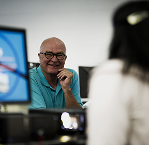
“It’s a good way to introduce young people to Urban Planning and GIS,” says William Huxhold, professor of architecture and urban planning and director of the program. “It’s a good way to expose them to careers and get them involved in their community.”
In previous years the students have undertaken such ambitious projects as working with data to make recommendations for the Park East Freeway redesign.
This year, 14 juniors and seniors and 21 freshmen are taking part in two different sessions. The course is one of the career options in the Upward Bound Math and Science Summer Program. The Department of Urban Planning sponsors the program, which was originally developed using funds provided by the U.S. Department of Housing and Urban Development.
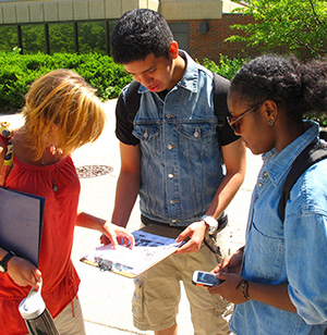
For two hours twice a week, each group of PUPS students completes a series of activities, often using real data and information from Milwaukee agencies. In one class exercise Huxhold developed, for example, the students simulate what the Milwaukee Police Department does with GIS by locating potential drug houses. The city data on factors common to drug houses – tax delinquency, vacancy, etc. – helped the students develop their own maps pinpointing houses that might pose a problem.
In the same class, they had a chance to talk to UWM alum Anne Reis, a GIS and field data specialist at the Urban Ecology Center, who showed them how the center uses GIS to track mammal and bird populations and plant species.
The students also got a chance to practice with GIS software, use the SimCity games in an exercise to build their own cities as a fun way to explore the impact of development, and use specialized cell phone apps to map locations around the UWM campus.
“It’s a structured exposure to the technology and skills needed in urban planning,” says Huxhold. Teaching assistants, all graduate students in geography, architecture, urban planning or the GIS certificate program, also work with the class.
“I really enjoy teaching the class,” says Huxhold. “These are great students and they come up with so many good ideas.”
The classes culminate with students doing a presentation about their own neighborhoods, including maps, statistics, pictures and videos. That work, says Huxhold, helps them make connections between their own neighborhoods and such concepts as zoning, transportation systems, and how the location of schools, grocery stores, police stations and other facilities impacts neighborhoods. “It also encourages them to get involved in their own neighborhoods, and lets them look at their own neighborhoods from a different perspective.”
“We’re using real-life data. That’s what makes this fun,” says Ashley Hoerz, one of the graduate students helping with the class.
“It’s fun … really fun,” agreed Abdullahi Ahmed, a senior at Clara Mohammed High School, who is interested in architecture and urban planning.
“The class teaches teamwork and shows us how we can use technology,” says Lathan Lucas, a junior at Morse Marshall High School. He’s planning a career in software engineering and saw the class as an opportunity to look at related career options.